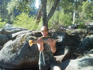
I have always heard stories about the huge trout that can be found in the San Joaquin River above Mammoth Pool Reservoir . I have also heard the horror stories about the steep terrain and abundant rattle snakes can be found in the river canyon. Recently my brother in-law Forrest began discussing his last trip to the area, and showed me some pictures of very large Brown Trout that were caught on the excursion. When he began discussing the possibility of visiting the area that weekend, I knew that I had to take the opportunity to go with him. Now, I had just turned 44 and was in the worst backpacking shape of my life, but I just could not allow this opportunity to pass by. We made our plans and agreed to meet at 4am that Saturday morning.
To gain access to the trail head we took Beasore Rd out of the Bass Lake area and followed it for quite awhile. I don’t know how many miles we went on Beasore, but I can tell you that we turned left at a road with GPS coordinates 37°31.135’N and 119°16.588’W.
My GPS map called the road “Layati.” (Many of these roads are dirt and a 4X4 vehicle are suggested). We continued on this road until we reached the trailhead at 37°30.143’N and 119°14.578’W. (This is not technically the Hells Half Acre trail) South of this trailhead is the real Hells Half Acre trail, however I am not sure that there is access to the river in
that area due to the steep cliffs.
Locals tend to call anything between Mammoth Pool and the confluence of North Fork and Middle Forks of the San Joaquin by this name. I know this is a silly name for a 15 mile stretch of the San Joaquin, but when a large group of peers only know that area as Hells Half Acre, it kind of sticks. The trail that we took was called the Cassidy Trail or as listed on my GPS, the California Riding and Hiking Trail. It started at 6500 feet in elevation. Our final destination was about 4500 feet elevation. We followed the Cassidy Trail until we reached coordinates 37°29.378’N 119°13.166’W, and at that point we left the trail that went east and headed in a northerly direction. Keep in mind that Forrest was guiding this excursion without the use of a GPS. We were essentially just kinda feeling our way to the destination, but don’t get me wrong, Forrest knew where he was going in this area of the Sierras.
Along on this trek were two freinds of ours, Josh and Devon Chaney. One of my fears were the rattle snakes that are rumored to plague the area. Josh wore snake gatters, and as we were hiking he proceeded to tell me that his primary goal on this trip was to find and kill rattlesnakes for a local game feed. After 2.5 hours and 3 miles of cross country hiking with a 40 lb pack, I really began to feel bad. I was able regain my composure and finish the remaining mile of
steep decent on granite rock faces within an hour.
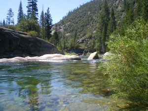
Our camping site was awesome. It was an island created by a small offshoot of the San Joaquin and was covered with large Black Oak, Cedar and Pine trees. Much our camping area was covered in a foot of sand making it a very comfortable place to hang out and sleep.
The river was abundant with insect activity but I only saw an occasional fish rise. I caught about 6 small to medium size rainbows, with the largest being about 12 inches. No 20 inch Brown Trout for me on this trip.
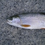
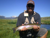
The water seemed to be loaded with fish, but it was difficult for me to get my line deep enough to get to the big ones. The river was very swift because of the late snow melt. The fish would hit any type of dry or wet fly when properly presented. (As you can see to the left, the small trout are pretty fat) I noticed orange fins on one of the Rainbow Trout which was a sign of Golden Trout hybridization.
The trek out of the canyon was punishing. We took a longer route out of the canyon. Because if this it ended up taking me 8+ hours to complete the 6 mile hike. I went thru my two litres of water within the first two hours of the trek and my surgically reconstructed knee was really hurting . With a lot of support from the others in my party, and several 800 mg Ibuprofen, I was able to make it out alive and in one piece. I did not see one rattle snake.
Thank you Forrest, Josh and Devon.


Great article.
Did you see any bears? Or any deer? I know they migrate across Mammoth farther downstream. We had trouble with bears several years ago.
Hi Denis,
I did not see any bears, but plenty of bear sign. They are certainly around. This trip was taken on opening day of bow season for deer and we did not see any. I think they close Mammoth Pool in the late spring to accommodate the migrating deer.
Thanks for visiting my site!
Sean
Your welcome.
I visited HHA 10-15 years ago. Can’t remember much except how steep it was coming back up, great fishing and lots of bear sign. We did not see any snakes on out trip.
You mentioned you took a different trail back that was longer. Can you explain? I thought there was just one route in and out from the HHA trail head off of Minarets Road. Did the Forest Service build new trails.
Thanks,
Denis
We actually took the Cassidy Trail rather than the HHA trail. We followed the Cassidy Trail for a while and, then we went off the trail, cross country to the North just before the trail steeply descends into the river canyon. So, all of the hard part descending and ascending was off the trail. Brutal! On the way back, we went down river for a while before beginning the ascent and due to the difficulty of the terrain, we got far off track.
Sean
So from the Minarets road trail head how good is the trail going down? Is it easy to follow?
Hi Denis,
The trail itself is a good trail and easy to follow.
Sean
Much appreciated for the information and share!
Nancy
Hi Nancy,
I am glad that you found it helpful. Thanks for checking it out.
Sean
Thanks for the story. I just finished that brutal Cassidy Trail with some friends and still suffering from the punishing hike. Fly fishing was awesome and we decided to visit it again some year. I’m almost 50 and my buddies are between 22 and 30. I outhiked all of them.
Hi Scott,
Sounds awesome. It is a brutal hike, but worth every painful step. So far this year, I have not had time take a another trip down into the SJ river canyon, due to buying a fixer-upper near Bass Lake. Keep in touch.
Sean